By Liliana Usvat
Blog 265 -365
To replant trees where the soil has been lost there is a need for water. I am presenting some methods that conserve water and move it to plants or other places. And then some gravity water systems used in the past some that are still in use today.
With any slope, gravity will move things from the highest point to the lowest, and we can take advantage of the work performed by gravitational force to make our system more energy efficient. The main emphasis of designing with slope is efficient energy flow.


When dealing with gravity flow systems your water supply is effected by at least three different factors. They are water availability, pipe size, and the elevation of the water supply above your irrigated area (known as “pressure head”). These are really the same factors that determine water supply for all irrigation systems,
A typical situation would be a small dam created using sandbags in a stream and a pipe is stuck in under the sandbags. Water collects in the area behind the sandbags and some of it is diverted into the pipe. Normally a piece of nylon or galvanized steel window screen or mesh hardware cloth is placed over the pipe inlet to keep out small fish and twigs. The pipe transports the water to the area you want to irrigate. The Bucket Method of measuring flow is pretty easy, but you may get wet!

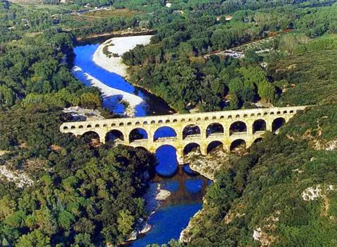
The grandeur and manpower strength of the Roman Empire and its robust capital of 1 million people was sustained by its 11 gravity-fed aqueducts that brought clean, wholesome water—in amounts comparable to what we enjoy today--over a 306 mile network through settling and distribution tanks to supply 1,352 public fountains and basins for drinking, cooking, and cleaning, 11 huge imperial baths, 856 free or inexpensive public baths, private homes, before flushing out the city’s waste to the Tiber through an extensive sewer network.
The Persian Garden developed in the mountainous plateau which formed the central area of the Persian Empire. There water was a priceless commodity. This was reflected in the traditional Persian Garden which was composed of four essentials: water for irrigation, display and sound, shade trees for shelter, flowers for scent and colour, and music to delight the ears, a typical garden design found from Persia to Spain and in many old carpets and miniture paintings is a quadrant pattern with water channels dividing the garden into four sections


What technologies were used to collect, channel, redirect and conserve water in Medieval Andalus? Rainwater was collected from ceramic-tiled roofs through a system of gutters and pipes that moved the water to underground cisterns for storage. Water from the winter rains thus became available for summer gardens. Spain’s rivers, such as the Guadalquivir (Arabic: Wadi al-Kabir, or Great Valley), had a system of dams and flood control walls built by its Muslim rulers.

Aqueducts that had been built by the Romans were maintained and improved under Muslim rule to carry water from mountain streams to the cities and fields where it was needed. Some aqueducts let out into dancing fountains that worked without electric pumps (of course), by carefully harnessing the powers of gravity and water pressure using narrow pipes. Norias, or huge wooden waterwheels, were also carried over from Roman times and improved upon. Some norias are still functioning today.

Their purpose was to raise the level of water from the source into the canal system, and maintain this level. Irrigation of farmland was carried out thorugh a system of ditches and gates called in Spanish acequia (Arabic al-saqiyyah, “to quench”), which spread to the New World with the Spanish, and is still used in the American southwest.
Links
https://www.youtube.com/watch?v=my8_4C1x0DI
https://www.youtube.com/watch?v=-y5AVEwDizM
http://en.wikipedia.org/wiki/Roman_aqueduct
Blog 265 -365
To replant trees where the soil has been lost there is a need for water. I am presenting some methods that conserve water and move it to plants or other places. And then some gravity water systems used in the past some that are still in use today.
With any slope, gravity will move things from the highest point to the lowest, and we can take advantage of the work performed by gravitational force to make our system more energy efficient. The main emphasis of designing with slope is efficient energy flow.
Water flowing , either from directly above as rain, from run-off coming from adjacent properties, or collecting in an area (such as a flood prone area) can he redirected into lakes, dams, ponds, irrigation channels, swales and other water management systems.
Wetter areas can be used specifically to grow very ‘thirsty’ plants and trees, which will help manage the excess water, or they can be converted to wetlands or bodies of water, such as ponds, lakes and dams for water storage.

Water can be captured at an elevated point on the site, and being elevated, it is a store of what they call ‘potential energy’ in physics. The water can then flow under gravity to perform work, such as irrigation or water supply.

When dealing with gravity flow systems your water supply is effected by at least three different factors. They are water availability, pipe size, and the elevation of the water supply above your irrigated area (known as “pressure head”). These are really the same factors that determine water supply for all irrigation systems,
A typical situation would be a small dam created using sandbags in a stream and a pipe is stuck in under the sandbags. Water collects in the area behind the sandbags and some of it is diverted into the pipe. Normally a piece of nylon or galvanized steel window screen or mesh hardware cloth is placed over the pipe inlet to keep out small fish and twigs. The pipe transports the water to the area you want to irrigate. The Bucket Method of measuring flow is pretty easy, but you may get wet!
Water
Water naturally flows from the highest point to the lower, so slope can be used to move water downhill by gravity.
- By situating water storage such as tanks or dams uphill on the higher points of a site, gravity alone can supply a flow of water without needing additional energy to power a pump.
- Gravel pits with reeds growing in them as a wastewater treatment system located downhill from the house, waste water (greywater) can flow under gravity into the reed beds, where it is cleaned, and then directed into a pond situated further down the slope.
- As an alternative to using a reed bed wastewater treatment system, the wastewater from the kitchen, bathroom and laundry can be directed to an orchard that is located downhill from the house.
- Structures that have a large roof areas for rainwater harvesting, such as sheds, workshops and other such buildings that people don’t live in can be located uphill from the house, to capture rainwater, which is collected in water tanks located next to these structures, and fed via gravity to the house.
The ancient water provision technology can be described as the greatest contribution made by Iranians to hydraulics. Before the Roman aqueduct.
The subterranean city in Kariz, Iran is more than 2,500 years old and covers an area of 10, 000 square meters. It has tunnels that are several kilometers long and roughly horizontal, with a slope. This allows water to drain out to the surface by gravity to lower and flatter agricultural land.
The people in Iran had developed their own hydraulic system called a qanat.

he Kariz, an irrigation system of wells connected by underground channels in Turpan area. The structure of the Kariz basically consists of wells, underground channels, ground canals and small reservoirs. In spring and summer, a great mount of melting snow and rainfall flow down from the Bughda and Karawuquntag mountains north and west of the Turpan

Depression into the valleys and then seep into the Gobi Desert. Taking advantage of the mountain slopes, the working people ingeniously created the Kariz to draw the underground water to irrigate the farmland. The water in Kariz will not evaporate in large quantities even under the scorching heat and fierce wind, hence ensuring a stable water flow and gravity irrigation. At its peak, the Kariz irrigation system exceeded 5,000 km (3,106 miles)

Nowadays, large stretches of fertile land are still irrigated by Kariz. It was build for agricultural as well as for residential use in 2000 years ago, dates back to 103 B.C. In 1950s there are 1984 of them, now only 614 of them have running water, rest are tried up. The official research concluded that the Kariz will disappear in next 25 years.

Generally, a Kariz is 3 km (1.9 miles) with the longest being 20 to 30 km (12-19 miles) with several dozen vertical wells. Sometimes the number of vertical wells exceeds 300. Until today, the shortest Kariz found is only 30 meters (98 feet) long.

The vertical wells are for ventilation, digging and maintenance of the Kariz . The bottoms of all the vertical wells are connected so that water can pass through. The underground canal is about 2 meters (6.5 feet) high and covered with earth to resist the heat.
The surface canals, connected to the underground ones, are not more than 1 meter (3.2 feet) wide with trees planted on both sides to prevent evaporation. The vertical wells near the water source may be 100 meters (328 feet) deep while further downstream they are less than 10 meters (32.8 feet) deep.
Roman Empire
When Roman cities outgrew their local water supply aqueducts were devised to bring in water from natural springs in the hills for public fountains, public baths, irrigation and industry. Above ground structures used a simple gravity system to carry water over a course plotted to maintain a uniform downward gradient.

Depression into the valleys and then seep into the Gobi Desert. Taking advantage of the mountain slopes, the working people ingeniously created the Kariz to draw the underground water to irrigate the farmland. The water in Kariz will not evaporate in large quantities even under the scorching heat and fierce wind, hence ensuring a stable water flow and gravity irrigation. At its peak, the Kariz irrigation system exceeded 5,000 km (3,106 miles)

Nowadays, large stretches of fertile land are still irrigated by Kariz. It was build for agricultural as well as for residential use in 2000 years ago, dates back to 103 B.C. In 1950s there are 1984 of them, now only 614 of them have running water, rest are tried up. The official research concluded that the Kariz will disappear in next 25 years.

Generally, a Kariz is 3 km (1.9 miles) with the longest being 20 to 30 km (12-19 miles) with several dozen vertical wells. Sometimes the number of vertical wells exceeds 300. Until today, the shortest Kariz found is only 30 meters (98 feet) long.

The vertical wells are for ventilation, digging and maintenance of the Kariz . The bottoms of all the vertical wells are connected so that water can pass through. The underground canal is about 2 meters (6.5 feet) high and covered with earth to resist the heat.
The surface canals, connected to the underground ones, are not more than 1 meter (3.2 feet) wide with trees planted on both sides to prevent evaporation. The vertical wells near the water source may be 100 meters (328 feet) deep while further downstream they are less than 10 meters (32.8 feet) deep.
When Roman cities outgrew their local water supply aqueducts were devised to bring in water from natural springs in the hills for public fountains, public baths, irrigation and industry. Above ground structures used a simple gravity system to carry water over a course plotted to maintain a uniform downward gradient.

The grandeur and manpower strength of the Roman Empire and its robust capital of 1 million people was sustained by its 11 gravity-fed aqueducts that brought clean, wholesome water—in amounts comparable to what we enjoy today--over a 306 mile network through settling and distribution tanks to supply 1,352 public fountains and basins for drinking, cooking, and cleaning, 11 huge imperial baths, 856 free or inexpensive public baths, private homes, before flushing out the city’s waste to the Tiber through an extensive sewer network.
The Persian Garden developed in the mountainous plateau which formed the central area of the Persian Empire. There water was a priceless commodity. This was reflected in the traditional Persian Garden which was composed of four essentials: water for irrigation, display and sound, shade trees for shelter, flowers for scent and colour, and music to delight the ears, a typical garden design found from Persia to Spain and in many old carpets and miniture paintings is a quadrant pattern with water channels dividing the garden into four sections
There was usually a pool or small hill with a pavilion at the intersection of the channels.
The Persian Influence is reflected after the Arabs overran the Persian Empire.
The Arabs developed the Persian style of garden in two principly different ways, namely the Mughul style,

best illustrated in the Vale of Kashmere and the Moorish style for which the works at Granada are the most famous.

What technologies were used to collect, channel, redirect and conserve water in Medieval Andalus? Rainwater was collected from ceramic-tiled roofs through a system of gutters and pipes that moved the water to underground cisterns for storage. Water from the winter rains thus became available for summer gardens. Spain’s rivers, such as the Guadalquivir (Arabic: Wadi al-Kabir, or Great Valley), had a system of dams and flood control walls built by its Muslim rulers.

Aqueducts that had been built by the Romans were maintained and improved under Muslim rule to carry water from mountain streams to the cities and fields where it was needed. Some aqueducts let out into dancing fountains that worked without electric pumps (of course), by carefully harnessing the powers of gravity and water pressure using narrow pipes. Norias, or huge wooden waterwheels, were also carried over from Roman times and improved upon. Some norias are still functioning today.

Their purpose was to raise the level of water from the source into the canal system, and maintain this level. Irrigation of farmland was carried out thorugh a system of ditches and gates called in Spanish acequia (Arabic al-saqiyyah, “to quench”), which spread to the New World with the Spanish, and is still used in the American southwest.
Links
https://www.youtube.com/watch?v=my8_4C1x0DI
https://www.youtube.com/watch?v=-y5AVEwDizM
http://en.wikipedia.org/wiki/Roman_aqueduct